
Key Highlights
- Geomorphology is one part of the UPSC syllabus. It is found in the physical geography section. It shows how the earth’s crust changes with time.
- You need to read about plate tectonics, continental drift, earthquakes, volcanoes, weathering, and main geomorphic processes.
- UPSC asks about these geomorphology topics in both the prelims and the mains. The exam also puts ideas close to things in India.
- Landforms made by rivers, glaciers, wind, coasts, and groundwater are very important here.
- Maps, diagrams, and looking at past questions help with revision. They make it faster and work well for the exam.
- Indian cases help to link theory with real things. This lets you answer questions better.
Table of Contents
Introduction
Geomorphology is a key part of physical geography. It gives you a good chance to score marks because it is based on clear ideas. You learn about how the earth’s surface forms and changes. These changes come from inside and outside forces. For UPSC, it is not just about knowing words or facts. You need to know about landforms, plate movements, weathering, and other steps in how things change. When you understand the basics, you find geomorphology easier to read again, link to Indian geography, and use it for both short and long answers.
Overview of Geomorphology in the UPSC Syllabus
In the civil services examination, geomorphology is a big topic in physical geography. It looks at the inside of the earth and the earth’s crust. It covers seismic waves, rocks, volcanoes, and earthquakes. You will also read about weathering, mass movements, and how landforms come up.
It also has plate tectonics, continental drift, and plate boundaries. The role of running water, wind, glaciers, groundwater, and waves shape the land. For prelims and mains, you need to know both the ideas and how they are used. The next sections will split this into parts you can study for the exam more easily.
Importance of Geomorphology for UPSC Prelims
For prelims, geomorphology is important. UPSC likes to ask questions about physical geography that focus on the main ideas. You might get questions about seismic waves, different kinds of volcanoes, weathering, karst features, river landforms, and the order of geomorphic processes. These questions ask for facts, but you still need to really understand them.
If you know plate tectonics and continental drift well, you can answer questions about major plates, fold mountains, the ocean floor, and earthquake zones with more confidence. The UPSC wants to see if you can link one idea to another. It’s not just about remembering facts on their own.
Your plan for prelims should be simple. You need to learn the definitions, steps, and some examples together. When you get how forces change the surface of the earth, it gets easier to rule out wrong answers in MCQs and get the right one.
Geomorphology and its Role in UPSC Mains
In mains, geomorphology is more than just naming landforms. You need to talk about causes, what happens, and effects. Questions may ask how plate tectonics theory helps us understand mountains, earthquakes, volcanoes, and changes in the earth’s crust.
This part is important because it connects to bigger ideas. Geomorphic processes have an effect on things like where people live, farming, getting around, water resources, and dangers like floods. This is where physical geography and human geography meet in a real way.
To write better answers for the mains, you should think about the structure, the process, and what is relevant. When you talk about a concept, try to tie it to India, disaster risks, or land use. This makes the answer balanced. It also helps to be more clear and useful for the GS paper.
Weightage of Geomorphology Topics in UPSC Exams
In UPSC exams, geomorphology is most often seen as part of physical geography. It does not usually come up as a separate topic. For prelims, the questions about it are direct or linked to different ideas. In mains, you will see questions about this area being more about analysis. This is true especially in the GS paper and for those who pick geography as an optional subject.
You need to focus more on some topics. These are the interior of the earth, seismic waves, earthquakes, volcanoes, continental drift theory, plate tectonics, weathering, and landforms that different agents make. These areas often give you the most value for your time and effort. If you get to know about plate tectonics, the idea of continental drift, seismic waves, and other related themes, it can help you do well.
| Exam Stage | Common Geomorphology Areas | Usual Nature of Questions |
|---|---|---|
| Prelims | Interior, rocks, earthquakes, volcanoes, landforms | Concept-based MCQs |
| Mains GS | Plate tectonics, hazards, Indian landforms | Analytical short and long answers |
| Geography Optional | Full geomorphology topics in depth | Theory, diagrams, comparison |
| Interview | India-linked geography understanding | Applied discussion |
Key UPSC Geomorphology Topics to Focus On
If you want to plan your revision, you should begin with the topics that make up the base of physical geography. Some of these topics are the evolution of the earth, the internal structure of the earth, different rocks, earthquakes, volcanoes, continental drift, and plate tectonics.
These topics will help you build a strong base in physical geography.
After that, go to geomorphic processes like weathering, mass wasting, river action, wind action, glacial work, coastal activity, groundwater features, and soil erosion. These topics help you often in GS exams and in optional answers. The subtopics below show what should get your top focus.
Structure and Evolution of the Earth’s Crust
If you know about the internal structure of the earth, it will help you answer a lot of questions in geomorphology. The UPSC wants you to learn about the layers of the earth. These are the crust, mantle, outer core, and inner core. The evolution of the earth starts from this point.
Seismic waves are very important for us to get information in an indirect way. When we look at body waves and surface waves, we can see how the layers inside the earth change. This helps geographers to know about density changes and seismic discontinuities. The ideas about seismic waves are tested in exams at the first stage and used as points for answers in main exams too.
You should also connect this with earth’s crust, plate boundaries, and how the land moves. When you see how the earth’s crust reacts where there are weak spots under it, it helps you understand why things like earthquakes, volcanoes, and new mountains happen. This makes the way the ground works easier for people to get.
Plate Tectonics and Related Landforms
For beginners, plate tectonics is a big idea in geomorphology. It tells how the major plates move and change the surface of the earth. This idea made old views, like continental drift, better.
You need to know the types of plate boundaries. It is important to see how plates move. These plate movements help shape the land around us.
Divergent margins can help you understand spreading zones. They play a part in how the ocean floor looks.
Convergent margins show why there are trenches in the ground. They also explain volcanic belts and fold mountains.
This topic gets better when you use both theory and examples. It helps you see why earthquakes gather in certain areas. It also shows how continents and oceans are set in the world, and how crust moves to form big land features.
Volcanism and Earthquakes in India
In India, earthquakes and volcanoes are important. They show the link between the shape of the land and natural dangers. UPSC questions can be about seismic zones, what causes earthquakes, or how the Indian plate makes the area unstable.
You need to know how plate boundaries affect the number of earthquakes in the Indian subcontinent. The way seismic waves move helps us learn about how these earthquakes happen. The way they are spread out shows why some places get more earthquakes than others. This is important and will help you give better answers in GS about disaster management as well.
Volcanic activity is also included in the syllabus. You will learn about different types of volcanoes and volcanic landforms. The Indian examples may be few, but that does not make this idea less important. It connects geological processes with risk, land shapes, and where people live.
Weathering and Mass Wasting
Weathering happens when rocks break down at or near the surface of the earth. There are three main types. These are chemical, physical, and biological weathering. UPSC likes to test if you can tell the difference between them. It also checks if you know the reasons for each one.
Mass wasting is when things move down a slope because of gravity. It happens slowly sometimes or very fast, like during landslides. These are some of the main geomorphic processes. They change the way slopes look, make the ground less strong, and can cause problems with land staying in place.
Together, weathering and mass wasting shape soil erosion, slope change, and how landforms grow over time. If you learn this topic well, you will be able to answer both simple and tough questions. This can help when people ask about hills, hazards, and environmental issues in India.
Soil Formation and Classification
Soil is not something different from geomorphology. It comes about over a long time as rocks, climate, land shape, plants, animals, and time all work together. That is why when we study how soil is made, we also need to look at landforms and how rocks break down with weather.
UPSC wants you to have a clear idea about what makes soil grow and change. You should also know about the different stages, soil layers, and kinds of soil. The physical setting of a place affects how deep the soil will be, how it feels, and how much it can help plants grow. Natural vegetation has a strong effect on the amount of living stuff in the soil and what the top of the soil is like.
This topic gets more useful when you link it with soil erosion and conservation. In India, it helps you understand agriculture, land use, and how we can do sustainable land management. For geography optional, it acts as the main connection between geomorphology and other parts of physical geography.
Geomorphic Processes and Landform Development
Geomorphic processes show us how landforms are made, changed, and broken down. In physical geography, you can see these processes as internal and external actions. Internal geological processes are things like tectonic activity, earthquakes, and volcanism.
Rivers, glaciers, wind, groundwater, and waves slowly change the land. They do this by wearing away, moving, and putting down rocks and soil. Plate tectonics shapes the main structure of the land first. These surface agents then work on it as time goes on. You will read about each of these big agents in the next sections.
Fluvial Processes and River Landforms
Running water shapes the surface of the earth in big ways. It changes the ground through fluvial processes like erosion, moving things, and laying them down. UPSC asks about river development stages, and what landforms are linked to each stage.
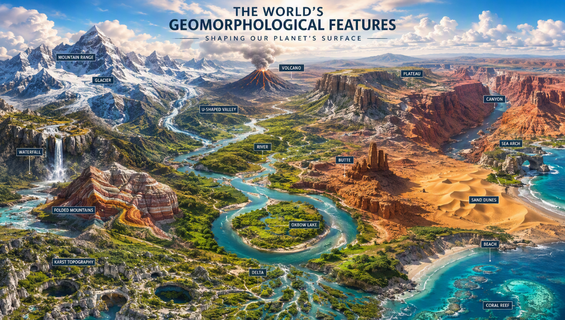
Some of the main landforms shaped by erosion in rivers are valleys, gullies, gorges, canyons, potholes, and river terraces. Landforms made by sediment building up include alluvial fans, floodplains, natural levees, meanders, point bars, oxbow lakes, and braided channels.
This topic is not just something you read about in books. The way rivers shape land matters a lot in the real world. River landforms affect farming, where people live, and water resources. If you can tell how a river changes its load, slope, and the way it flows, you will be able to give better answers about how landforms form and about the Indian drainage systems.
Glacial Processes and Associated Features
Glacial processes matter, even though glaciers cover only a small area. In physical geography, they help us see how ice can wear away rocks, move stuff, and drop what it carries. UPSC might ask questions about glacial landforms that come from both wearing away and dropping material.
You need to know about cirques, arêtes, glacial valleys, troughs, and fiords that come from glacial erosion. On the other side, glacial deposition gives us things like moraines, eskers, drumlins, tills, and outwash plains. These features help us see how glacial action is different from what rivers or wind do.
This topic helps you learn about climatic changes and how they impact mountain environments. If you are taking geography as your optional subject, you have to read this. It helps you know about the main processes, show how to spot different landforms, and ties in to what the climate was like before and what it is like now.
Aeolian (Wind) Processes and Desert Landforms
In dry climatic regions, the wind plays a big role in shaping the land. The wind’s actions be called aeolian processes. These include deflation, abrasion, moving things from one place to another, and putting things down. UPSC talks about these as major agents that shape landforms, and they often ask questions about desert landforms.
Some landforms are shaped by wind wearing down rocks. These erosional features are called pediments, pediplains, playas, deflation hollows, caves, mushroom rocks, table rocks, and pedestal rocks. The wind can also build up new shapes. These depositional features include barchans, seif dunes, transverse dunes, parabolic dunes, and longitudinal dunes.
You should also tie wind action to soil erosion, especially when you talk about arid land management. Surface waves are part of earthquake study, but wind-shaped surfaces help us learn about desert areas. This topic is very helpful when you connect it with Indian deserts and dryland geography.
Coastal Processes and Shoreline Landforms
Coasts change because of waves and currents moving ocean waters. This happens over a long time. There are some main things that shape coasts. These are erosion, transportation, and deposition. UPSC can say something about both kinds of coasts. There are high rocky coasts and there are low sedimentary coasts.
Common shoreline shapes made by erosion are cliffs, terraces, caves, and stacks. The landforms built by things being moved and dropped off are beaches, dunes, bars, barriers, and spits. These are some of the main examples you may see in the bigger exams, and they often help when making diagrams.
This area links to the use of marine resources and how we manage the coast. Coral reefs are part of the larger world of the ocean, but they also help us know more about places near the shore. If you know how each of these features forms, your answers will be better and much clearer. This makes what you say strong and easy to follow.
Karst Topography and Subterranean Landforms
Karst topography forms mostly in limestone areas. Over time, water underground wears away the rock by dissolving it. This is an important part of physical geography. It helps us see how chemical things happening under the ground can make special land shapes.
You should get ready to know swallow holes, sinkholes, dolines, uvalas, and valley sinks, as they are shapes made by erosion. Stalactites, stalagmites, and pillar columns are shapes that are made where things are left behind inside the earth. UPSC asks students if they can spot these landforms in the right way.
For those taking geography optional, karst is a good topic to learn well. It is based on ideas and is easy to show with diagrams. This topic helps you see the way that rocks water can pass through, water going down into the ground, and underground streams help make landscapes that we might not see right away but are still important.
Application of Geomorphology in Indian Context
Geomorphology can help you understand the land better when you use it for the Indian subcontinent. The physical setting of India shows you a long story from its past. You can see the signs of plate tectonics and how land moves. Rivers shape the land, deserts also change it, and even the coast is always shifting.
These shapes of the land change how people use the land, find water, deal with dangers, grow crops, and decide where to live. UPSC often wants you to use Indian cases to show your point. In the next sections, you will see how the big landform areas of India can be understood by looking at them with a geomorphology view.
Geomorphological Features of the Indian Subcontinent
The Indian subcontinent has different types of land found in it. Its physical setting has changed because of things happening deep in the earth for a long time. The main land areas are the tall Himalayas, the Peninsular Plateau, the large Indo-Gangetic-Brahmaputra Plain, hot deserts, and land by the sea.
The Indian plate moves and meets other plates at plate boundaries. This is why mountains rise and there is seismic activity in the area. Over a long time, rivers and weathering work together. They shape the plains, valleys, and plateaus. Erosion also helps to form the land.
These landforms affect drainage, soils, natural vegetation, and how people settle. So when UPSC talks about India’s geography, geomorphology is the base. It lets you see how the land’s structure, the way things happen, and regional changes connect in a simple and clear way.
Himalayas: Origin and Evolution
The Himalayas are one of the best examples of fold mountains. You can see how they form by looking at plate tectonics. The Indian plate moves and pushes against another plate. This is how the Himalayas came to be. The way they formed makes them very important for people who study physical geography and the formation of fold mountains.
For UPSC, you need to know how things like compression, uplift, and crustal movement have made these young mountains. The fact that they are young is why the slopes are so steep, with a lot of erosion always happening. These areas are also not stable. That is why the Himalayan region is linked with some of the biggest seismic zones.
The Himalayas do more than just shape the land. They affect rivers, the climate, dangers in the area, and where people live. In geography optional, this topic is useful because it brings together ideas, the Indian setting, and gives you a good chance to use diagrams.
Peninsular Plateau and River Basins
The Peninsular Plateau is a very old and solid area of India. In physical geography, you can see that it is not like the young Himalayas. Its look shows many years of land wearing down, being steady, and land shapes changing over a long time.
This plateau helps to form big river basins. The slope of the land, the way the water flows, and the shape of the basins affect how rivers move to the east and west. These river systems are important for farming, for where people live, and for their water resources.
For the UPSC exam, do not read about the plateau as just one still area. Connect the rocks, the shape of the land, and the river basins with things like erosion, how water flows, and how the region grows. This will help you give an answer that is explained well with geomorphology instead of just saying what is there.
Indian Deserts and Coastal Areas
Indian deserts and coastal areas are a good place to study for exams. That is because they show two different things happening in nature. In the desert, wind shapes the land. On the coast, waves and water currents change the shoreline.
Desert features like dunes, pediments, and spots shaped by wind show us how dry land changes over time. Coastal places have cliffs, beaches, bars, spits, and wide sandy areas. These help in map work and to write or talk about what you see.
You should also link these regions with the sea and what can be found in or on the water, the dangers they may face, and how the area can grow or develop. Plate tectonics gives the main base for how the land is shaped. Still, in these places, most of the daily changes in the landscape happen because of the wind and the ocean.
Geomorphology and Natural Hazards in India
The study of geomorphology helps us understand natural hazards in India. When you know more about the way the land is shaped and the forces at work, you can better see why earthquakes, landslides, coastal erosion, and slope failure happen. This is why it is very important for GS.
Seismic waves show us how earthquakes happen and what they do. Volcanic activity also matters, mostly when we think about how the earth works. Coastal places face tropical cyclones. The shape of the land in these places changes how much damage people get and how unsafe they feel.
A good UPSC answer needs to talk about response and planning. Knowing about hazards helps people to be smart about sustainable land management. It also leads to safer ways to use land and brings in ideas that fit each region. This is the part where geomorphology is not just theory. It becomes helpful for running things, making rules, and keeping people safe.
Mapping and Diagrams: Visualization in UPSC Geomorphology
Using mapping and diagrams makes it easier to remember geomorphology. In UPSC preparation, you can understand many ideas better when you put them on a map or sketch out the process. This method helps a lot when you study Indian geography and questions about landforms.
Map-based questions help you check how well you know places. Diagrams help you make your main answers better by showing how things work in a simple way. If you make notes by topic and add small maps and clear sketches, you can save time when you read them again. The next parts will show you how to use both of these tools to get the most out of them.
Map-Based Questions in UPSC Geomorphology PYQ
Map-based questions in past year papers help you see how geomorphology links to a place. In Indian geography, you will find that relief and drainage are always linked to the physical setting. If you know your maps, you will do better in prelims and mains.
You need to look at previous year questions for each topic and find the ones that keep coming up. Even if a question is not only about maps, it helps to know the location. This can make your answers better and give more clear details about each region.
Focus your mapping practice on:
- The Himalayan region is known for its large mountains and the seismic belts where earthquakes often happen.
- The Peninsular Plateau is an old part of India, and it has several major river systems that flow through it.
- There are many desert areas in India, like the Thar Desert, and the country also has long coastal stretches next to the sea.
- India is home to important land forms such as plains, plateaus, and also several fold mountains.
This way, you can make your own set of questions from PYQ. It also lets you go over them with a clear aim in mind.
Tips for Drawing Effective Diagrams in Mains
In UPSC mains, a simple diagram can make an average answer better. You do not have to be good at drawing. What you need is clear labels and to keep it about the topic. In physical geography, diagrams can show geomorphic processes faster than writing long paragraphs.
Keep your sketches simple. Make sure they match what the question asks for. A sketch of a river bend, where plates meet, a tall folded hill, a volcano, or a cave made from rock can help. These can make your answer easier for people to understand. It also helps you stay organized.
Use these drawing tips:
- Keep lines clean and make sure labels are straight.
- Draw only the parts you need for the answer.
- Add arrows to show which way the process goes.
- Practice sketching landforms the usual way many times.
If you make a fixed set of diagrams, it will help you with revision. Your mains presentation will also get better by doing this.
Key Map Points Related to Indian Geomorphology
When you study Indian geography, you should not do map work at random. It helps to make a short list of key geomorphological features. This list can support your answers on many topics. Doing this makes map work a strong tool for revising in physical geography.
When you make topic-wise notes, try to mark features by process and by region. This way, you do not just try to memorize places. You start to see why each region looks this way and how it fits in with big landform questions.
Mark these map points regularly:
- Himalayan arc and main earthquake areas
- Peninsular Plateau and big river basins
- Desert belt with places where sand dunes are many
- Coastal areas, river deltas, and coastal spots linked to islands
This kind of mapping helps give structure to your notes. It also makes it easier for you to remember things for both prelims and mains.
Preparing for UPSC Geomorphology: Strategies and Resources
The best way to get ready for UPSC geomorphology is to go from basic ideas to how you use them. First, you need to understand the main points well. After that, link these ideas to Indian examples, maps, PYQ, and short notes.
It is best to keep your resources and study material simple so you can read them again. Stay focused on the topics from your syllabus and do not read more than you need. With a good plan, geomorphology will feel easier and you may even enjoy it. The next parts will show you how to prepare in a way that works.
Identifying High-Yield UPSC Geomorphology Topics
Not every topic needs to get the same amount of time. In geomorphology, some topics often help for prelims, mains, and Indian geography. These topics give more marks. You should look at these topics first, mostly if you are just starting.
One good way is to choose ideas like plate tectonics that help you explain many other topics. For example, earthquakes, weathering, and landforms shaped by big forces all link well with this theme. They show up often. You can find them in different ways across papers too.
Start with these high-yield topics:
- The inside of the earth and seismic waves
- Plate tectonics and how continents move over time
- Volcanoes, earthquakes, and fold mountains
- Landforms made by rivers, ice, wind, sea, and karst shapes
If these are strong, your bigger plans get more steady. You also use your time better.
Creating Effective Topic-Wise Notes
Yes, topic-wise notes can be one of the best ways to prepare for UPSC. But the notes must be short, well-organized, and simple to review. Good geography notes often use headings, drawings, and repeat question types.
Don’t make your notes read like a textbook. Try to divide each topic into these parts: meaning, process, landforms, examples, and how it matters in India. This is a simple way to study. It helps you save time right before exams and makes it easier to remember what you read.
Your notes can include:
- There is a one-page summary for every chapter.
- You will find small diagrams that show landforms which come up a lot.
- There is a different part about themes based on Previous Years’ Questions (PYQ).
- A “map corner” is included with Indian examples and different regions.
If you take notes like this, you can go over your work faster. It also helps you write better and more exact answers.
Recommended Books and Study Material
In geomorphology, the best study material is the one you can read and revise more than one time. This subject is part of geography and physical geography. Your materials should help you know how the different things happen, not just help you remember a list of facts.
The compiled syllabus is a good guide. It shows you the full list of topics you need to know. You should read based on the syllabus, class notes, PYQ, and practice maps. This helps you stay on track. It keeps you from getting too much information that is not needed.
Your core study set should include:
- The official geography syllabus topics list
- Notes from your class or notes you made about geomorphology
- Previous year questions sorted by topic
- Practice sheets with maps and diagrams for review
If you use this small set all the time and practice it often, it will be enough.
Integrating Current Affairs with Geomorphology Preparation
You should not see current affairs as something apart from geomorphology. A lot of news about Indian geography talks about landforms, hazards, erosion, water systems, and environmental issues. These topics help make your main answers better.
The main thing is to link news stories with the fixed ideas you learn. For example, when you read news about landslides, cyclones, erosion, or glacial changes, put these events under the right geomorphology topic. This helps to turn all that information into something you can really use when you prepare.
Track current affairs linked with:
- Earthquakes often happen in areas where there are a lot of movements under the ground. These regions can feel strong shakes that can change the land.
- Coasts change shape over time because of coastal erosion. Tropical cyclones can make these changes much faster by pushing water and wind on the shore.
- Climatic changes can change how big glaciers are and how rivers flow. When the weather shifts, glaciers might melt faster, and rivers may have more or less water.
- Land can wear away as soil erosion takes place. This, along with land getting worse for farming or living, can lead to problems. There are also issues about how to keep the land safe with conservation ideas.
This way helps make your answers better because they fit what people want. You also will not have to read a lot more text.
Analysis of UPSC Geomorphology PYQ and Practice Questions
PYQ analysis helps you learn in a better way. In UPSC geomorphology, you can see that some topics keep showing up in old questions, even if the words change. This shows that looking at trends is often better than only guessing what will be asked.
When you know the pattern, practice questions feel easier. You start to see what the UPSC looks for. They want clear answers. They also want to see if you understand the steps and can use them. In the next parts, we will look at question trends. We will talk about topics that come up many times and the answer mistakes that people make often.
Trends in UPSC Geomorphology PYQ Over the Years
A clear pattern shows up when you look at UPSC PYQ in geomorphology. The exam goes back to a few main ideas many times. The way questions are written may not be the same each time. But, if you look at the questions closely, you will see they come from the same topics.
In prelims, you will get questions that are clear and test your understanding of ideas. In mains, you have to explain those same topics more. You may need to compare things, describe details, and show how it fits in India. That is why going through PYQs is one of the best ways to revise.
| Area | Prelims Trend | Mains Trend |
|---|---|---|
| Interior and seismic waves | Definition and identification | Explanation of structure and relevance |
| Plate tectonics | Boundaries and movements | Theory with landform application |
| Rivers and landforms | Feature recognition | Process-based discussion |
| Hazards | Basic concepts | India-linked analytical answers |
So, a close look shows that there is repetition, but each time it is a bit different. It does not look like random questioning at all.
Frequently Asked Geomorphology Questions in UPSC
If you need a practical question list, start with the themes that UPSC asks about again and again. These are often about big processes, landforms, and certain important theories. They help with both the prelims and mains.
Many people want to know where they can find questions and answers by topic. The best way is to use your own previous years’ questions (PYQs). Sort these questions by main topics. When you do this, you will see the important areas for the exam very fast.
Commonly repeated themes include:
- Plate tectonics is a big idea in earth science. It talks about how the pieces of the Earth’s crust move. This movement helps make new landforms. Landforms like mountains, valleys, and plains form when these pieces shift or bump into each other. That is why plate tectonics is so important. Mountains can rise, and valleys can split open all because of this movement.
- Weathering, erosion, and mass wasting are ways rocks and soil change on earth. Weathering breaks rocks into smaller pieces. Erosion moves these pieces by water, wind, or ice. Mass wasting happens when soil and rock slide downhill because of gravity. The big difference is weathering stays in one spot, erosion takes things away, and mass wasting usually flows fast down a slope.
- A river shapes the land as it moves water. A river creates different landforms, like valleys, floodplains, and deltas. There are several stages for fluvial development. In the first stage, rivers start out small and flow steeply. As time goes on, the river may get wider and make bends called meanders. Later, it can lay down more soil near its mouth and form a delta. These stages change rivers over time.
- Earthquakes happen when the earth shakes from deep underground. The shaking is caused by seismic waves. These waves move out from the spot where the earthquake started. Volcanic activity is when a volcano lets out lava, ash, or gas. Both earthquakes and
This question list can help you set up your plan for revision.
Sample Topic-Wise Practice Questions
Topic-based practice questions help you change from just reading things to starting answer writing. For UPSC and geography optional, it is good to have practice sets that are arranged chapter by chapter. This way, your work will be more focused, and you can also see how much you have done.
You can make your own list from PYQs for UPSC and other exams. Sort these questions under the main parts of the syllabus. Then, add some questions you make yourself. This helps check if you and others understand, not just remember things.
Practice with questions such as:
- Seismic waves give us a way to learn about the earth’s interior. When there is an earthquake, these waves move through the earth. They travel at different speeds and paths in the earth. By studying how these waves move, where they speed up, and where they slow down, people can tell what the earth is made of in each layer. So, they help scientists know what is inside the earth, like what the core, mantle, and crust are made of.
- The continental drift theory is very important in modern geography and earth science. It says that land on the earth, called continents, was once joined together but then moved apart over time. This idea helps people know how continents like Africa and South America were once close together. The theory explains how and why continents move and the way the earth’s surface looks now. The keyword “continental drift” comes from this theory, and now scientists use it to study where earthquakes and volcanoes happen as well.
- Alluvial fans form where a river or stream quickly slows down, losing speed as it moves out from hills or mountains onto flat land. Sand, rocks, and dirt in the water then fall out in a fan shape on the land. A delta forms where a river meets a lake, sea, or ocean and drops dirt and silt to build up land in a triangle or fan shape. Oxbow lakes form when a river bends a lot and creates loops. Over time, the water cuts through the narrow part of
This way of practice helps you get better at the subject. It also helps you write better answers for exams.
Common Mistakes to Avoid in Geomorphology Answers
In the civil services examination, many students know the words and ideas, but they still lose marks in geomorphology. This is not because they do not have enough content. The main reason is often a weak structure, not enough explanation, and missing how to use what they know.
A good way to write answers is not to fill them with just definitions. The UPSC wants to see that you know the steps in the process. Answers should also have the right order and, if you can, link them to India. You can use diagrams too, but only add them if they help explain the answer.
Avoid these common mistakes:
- Some people mix up weathering with erosion or deposition.
- Some write about plate tectonics but do not explain what boundaries are.
- Some just list landforms but do not show how these are made.
- Some do not use diagrams, maps, or Indian examples when these are needed.
If you fix these habits, your answers will get better. People will see them as more clear and true.
Role of Geomorphology in General Studies and Interview
Geomorphology is important in general studies. It helps answer questions about land shapes, dangers, natural resources, and growth in an area. It starts in physical geography, but it can also be part of talks about how we govern and make rules for the land.
In the interview, having basic knowledge of geomorphology helps you feel sure when you answer questions about places and problems. It is also easy to connect geomorphology with human geography because the shape of the land affects where people live, how land is used, and how areas might be at risk. The next sections will show how these ideas link together.
Relevance in UPSC GS Paper I
Geomorphology is very important for GS Paper I. It is the base of physical geography. There are many questions about earthquakes, mountains, landforms, and natural regions that often use ideas from this area. Even if the word geomorphology is not in the question, you still need to know about it for GS Paper I on physical geography.
For example, if you get a question about mountain building or earthquakes, you need to know about the major plates and plate boundaries. If the question is about the relief regions of India, you should talk about how these places changed over time because of different processes.
This is why you should not read geomorphology by itself. It helps you answer broader geography questions in the GS Paper I. It lets you write with more clarity, better structure, and with stronger ideas. This topic can make several areas better at the same time.
Application in Essay and Ethics Papers
At first, you may think geomorphology has nothing to do with essay writing or what is right and wrong. But in the civil services examination, there are many themes that need a strong understanding of physical geography. You have to know about the environment, keeping things in balance, dangers we face, and how people react to nature.
In essays, you can use geomorphology to talk about disasters, development, and how climate can make some places weaker than others. It helps you show facts and real-world examples in your argument instead of just ideas. This is good when you write about things like sustainability, resilience, and the environment.
Even in ethics, the way you use this knowledge is not always direct, but it is important. When people talk about public duty, dealing with disasters, using resources, and thinking about groups that need help, your points get better if the examples show you understand the land, dangers, and local situations that come from geomorphology. This helps make your answers strong and clear.
Geomorphology-Based Interview Questions
In the interview, the questions about geomorphology use easy words, but they need you to think and apply what you know. You may get questions about earthquakes in your area, where a plateau came from, how rivers act, or the way the shape of the land changes how people live and plan in your place.
If you have a calm feel for physical geography, you can talk about it without sounding like a robot. When you know the basics about the earth’s crust, plate movement, drainage, and landform regions, you feel sure about what you say. This helps you handle board questions with more confidence.
Interview talks may also link relief to population distribution, land use, how hard it is to get around, or risk from hazards. So, even at this point, geomorphology stays important. It helps you look at areas as a whole, say what is happening in a clear way, and answer with good ideas that people can use.
Advanced UPSC Geomorphology Topics for Optional Paper
In advanced UPSC Geomorphology, you get to learn about some interesting and important ideas. You look into complex geomorphic processes and how they shape the world you live in. Topics like plate tectonics and continental drift show how the Earth’s surface changes because of moving plates. When you study how fold mountains form from plate movements, you can better understand physical geography.
You need to look at things like coastal processes too. For example, the effect of ocean currents and what happens on the sea floor both tell us a lot about how land changes over time. All of this helps people make good choices about managing land.
When you learn about these things, you get the tools to work out ways to solve some of today’s environmental problems. You can also see how these issues affect the lives of people. Knowing these concepts about geomorphic processes and land types will help anyone get ready for the UPSC exam and do well in their studies.
Applied Geomorphology and Human Impact
Understanding how geomorphology works helps us see how people change the land. When cities grow, they can cause soil erosion and change how water flows. This can hurt natural vegetation and affect the local ecosystems. Mining and farming can also change landforms. These activities add to population growth.
By using applied geomorphology, people can look at how these changes affect energy resources and food security. It has a significant role in making good plans for sustainable land management. These plans think about how human geography and the earth’s surface work together. They help us find ways for development that still take care of the environment.
Recent Advances and Research in Geomorphology
Recent studies in geomorphology now show there is a strong link between the earth’s natural changes and what people do on the land. With new remote sensing tools, we are seeing more about how geomorphic processes work, like soil erosion and how land use changes over time. Many researchers look at the effects of climate change on landforms, and they are studying what happens when sea levels go up or storms get stronger, especially along the coast.
Using GIS with environmental modeling is also helping us see how the evolution of the earth affects human geography. This is important because it helps us figure out better ways for sustainable land management.
Integrating Geomorphology with Environmental Geography
Understanding how geomorphology and environmental geography connect helps us see how Earth’s surface shapes different ecosystems. The way geomorphic processes work, like soil erosion and land use, has a big impact on human geography and how resources are spread out. When we bring these fields together, we get a better look at things like river systems, coastal areas, and mountains. This helps us make good choices for sustainable land management. Also, knowing about plate tectonics and changes in climate lets us handle environmental issues, such as food security and population growth, in a smart and balanced way for the future.
Conclusion
To sum up, learning about advanced UPSC geomorphology topics helps us understand how the world works. When you study basics like plate tectonics and the theory of continental drift, you start to see how Earth’s past and present connect. Knowing about geomorphic processes lets us see environmental issues in a new light. This also helps us handle resources better, which is important for development that lasts. When students go through all these topics, they not only get ready for exams, but they also see how people and the environment are linked. Each idea they learn can help us all make smart choices for a healthy planet.
Which are the most important UPSC geomorphology topics for beginners?
For anyone new to UPSC geomorphology, it is important to start with the basics. You should know about landforms, the ways land gets shaped by erosion, and the idea of tectonics. Learning these will help you build a strong base. This knowledge will make it easier for you to understand harder topics and see how they are useful in the real world.
How can I make effective topic-wise geomorphology notes for UPSC?
To make good geomorphology notes for UPSC, use short summaries, clear diagrams, and mind maps. Break down the content by themes. Put important ideas first and read your notes again and again. Add new research and findings to help you understand and remember the key points.
Where can I find upsc geomorphology PYQ and comprehensive question lists?
For UPSC Geomorphology previous year questions (PYQs) and full question lists, you can go to the official UPSC website. You may also find what you need on many study material websites, or by joining online groups where people getting ready for the exam share their resources. Using these sources can help you get ready in a good way for your optional paper.